North Korea is Burning

Or, at least, large portions of it were burning when this satellite image was taken.


(AQUA satellite image of smoke plumes from fires in North Korea, 25 April 2014. NASA image.)

As this ABC News story noted,

The extent of deforestation stands out in the satellite image — in stark contrast to the greenery south of the DMZ in South Korea.

I primarily posted this because one of the fellows I worked with at the Defense Technology Security Administration had worked on the AQUA satellite, which took the image, when he was with NASA. Here’s the original NASA story with details on the image and the instrument used to produce it.

Facebooktwitterpinterestlinkedinmailby feather

GeoEye One

Five years ago today — September 6, 2008 — a Delta II rocket launched from Vandenberg AFB carrying a privately-owned remote sensing satellite.


(GeoEye 1. Image from the Satellite Imaging Corporation web page.)

Despite being privately owned and operated, one of GeoEye 1‘s main customers for its multi-spectral images is the Department of Defense. You can see a selection of GeoEye imagery in this gallery.

And on the same day that GeoEye 1 launched, the Chinese launched two environmental monitoring satellites, Huan Jing 1A and Huan Jing 1B, from the Taiyuan launch site on a Long March 2C rocket.

So, 5 years ago today was a good day for remote sensing!

Facebooktwitterpinterestlinkedinmailby feather

On My Way Out the Door: First Afghani Cosmonaut, and Five German Satellites

I’m headed to Dragon Con in just a little while! But first …

Twenty-five years ago today — August 29, 1988 — a Soyuz rocket out of the Baikonur Cosmodrome carried the first Afghani citizen to fly in space.


(Soyuz TM-6 insignia from Wikimedia Commons.)

The Soyuz TM-6 crew consisted of Russian cosmonauts Vladimir A. Lyakhov and Valeriy V. Polyakov, plus Afghani cosmonaut Abdul Ahad Mohmand. They spent a little over a week on the Mir space station before returning to earth.

In other space history, on this date 5 years ago another mission from the Baikonur Cosmodrome carried five German remote sensing satellites known as RapidEye-A through -E.

And speaking of remote sensing, congratulations to the Delta 4 launch team for successfully launching a National Reconnaissance Office satellite yesterday from my old stomping grounds, Vandenberg AFB!

Facebooktwitterpinterestlinkedinmailby feather

First Ocean-Watching Radar Satellite

Thirty-five years ago today — June 27, 1978 — an Atlas-Agena launch vehicle out of Vandenberg AFB carried the SeaSat-1 observation satellite to orbit.


(SeaSat 1. NASA image.)

SeaSat 1, also known as the Ocean Dynamics Satellite, was “designed to provide measurements of sea-surface winds, sea-surface temperatures, wave heights, internal waves, atmospheric liquid water content, sea ice features, ocean features, ocean topography, and the marine geoid.”

SeaSat 1 was the first synthetic aperture radar satellite designed to monitor the oceans from space, but unfortunately a “massive short circuit in its electrical system” in October 1978 cut the mission short. Nevertheless, SeaSat 1 “returned a unique and extensive set of observations of the earth’s oceans” and, according to this mission page, also demonstrated “the feasibility of global satellite monitoring of oceanographic phenomena and [helped] determine the requirements for an operational ocean remote sensing satellite system.”

Facebooktwitterpinterestlinkedinmailby feather

First Titan 34D Launch from Vandenberg

Thirty years ago today — June 20, 1983 — a pair of satellites were launched from Vandenberg AFB atop a Titan 34D booster.


(Titan 34D launching from Cape Canaveral. DoD image from Wikimedia Commons.)

Launched from Space Launch Complex (SLC, pronounced “slick”) 4-East, the two DoD satellites were designated 1983-060A (or 14137) and 1983-060C (or 14139), but a 2011 Space Review article identified the primary payload of this particular launch as a KH-9 reconnaissance satellite. The Titan 34D Wikipedia page notes the June 1983 launch as the first Vandenberg launch for the 34D configuration.

As an old Titan System Program Office guy, I’d just as soon end there, but as an old Vandenberg guy I’ll toss in another space anniversary: On this date 5 years ago, the French and U.S. Jason 2 satellite was launched from Vandenberg on a Delta II rocket. Jason 2 was designed to monitor oceanic conditions from space, and was “a cooperative mission involving the French CNES, the European EUMETSAT, and the American NOAA and NASA.”

Facebooktwitterpinterestlinkedinmailby feather

Exploring the Evolution of Galaxies

Ten years ago today — April 28, 2003 — a Pegasus XL rocket carried a small spacecraft to probe the origin of stars and galaxies.


(A 2012 GALEX composite image of the Andromeda galaxy. NASA/JPL-Caltech image.)

Called GALEX, for GALaxy Evolution eXplorer, the spacecraft’s primary instrument was a telescope tuned to the ultraviolet part of the spectrum. With its mission now extended beyond the original 29-month timeline, GALEX is conducting “an all-sky imaging survey, a deep imaging survey, and a survey of 200 galaxies nearest to the Milky Way” in order to explore the origins of heavy elements, stars, and galaxies. You can find more information about the mission, including many stunning images, on this page

For more down-to-earth mapping purposes, on this date 5 years ago India launched CartoSat 2A, a remote-sensing satellite, along with 9 smaller spacecraft, from the Sriharikota launch center on a PSLV 9 rocket. Urban and rural planners use CartoSat’s data.

___

P.S. The full resolution JPEG (19.3 MB) of the Andromeda image above is here.

Facebooktwitterpinterestlinkedinmailby feather

Last Saturn-Apollo Block 1 Suborbital Test Flight

Fifty years ago today — March 28, 1963 — the Saturn-Apollo 4 mission was launched from Cape Canaveral.


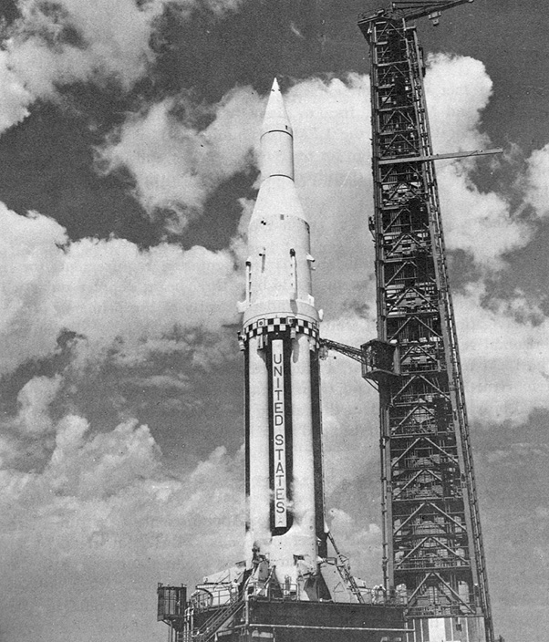
(Saturn SA-4. NASA image.)

Saturn-Apollo (SA) 4, or Apollo SA-4, was the final “Block 1” Saturn test, the last of four test launches of the Saturn rocket’s first stage.

The rocket was launched on a sub-orbital flight to an altitude of 129 km and a peak velocity of 5906 km/hr. After 100 seconds of flight, a pre-set timer cut off engine no. 5 as planned to test the “engine-out” capability of the booster. Fuel was successfully routed to the other seven engines and the flight continued.

Also on this date in space history, 30 years ago, the first of an advanced series of remote-sensing spacecraft, NOAA 8, launched into a polar orbit atop an Atlas E rocket out of Vandenberg AFB. Unfortunately, the satellite did not live out its two-year planned operational life: it failed in June 1984.

Finally, 10 years ago today — March 28, 2003 — Japan launched a pair of reconnaissance satellites, IGS (Information Gathering Satellite) 1A and IGS 1B, from Tanegashima Space Center on an H-2A rocket. According to the National Space Science Data Center, “One of the two spacecraft uses optical cameras with a resolution of one meter; the other uses synthetic aperture radar to provide images at a resolution of a few meters,” but it is unclear which satellite carried which sensor.

Facebooktwitterpinterestlinkedinmailby feather

Space History: the Nascent Strategic Defense Initiative

Thirty years ago today — March 23, 1983 — President Ronald Reagan announced a research program that would eventually become the Strategic Defense Initiative (SDI).

President Reagan called for a major research-and-development effort on space-based defenses against ballistic missile attacks. Some of the work I did in the Air Force was related to SDI, which became known (usually pejoratively) as “Star Wars.”

Those of us who were geeks of one stripe or another didn’t really mind the nickname.

According to this excerpt from Way Out There in the Blue: Reagan, Star Wars and the End of the Cold War by Frances Fitzgerald,

The announcement, made in an insert into a routine defense speech, came as a surprise to everyone in Washington except for a handful of White House aides. The insert had not been cleared with the Pentagon, and although Reagan was proposing to overturn the doctrine which had ruled U.S. nuclear strategy for more than three decades, the secretary of defense and the secretary of state were informed only a day or so before the speech was broadcast.

I find that fascinating: visionary, and quite bold. I appreciate that.

Facebooktwitterpinterestlinkedinmailby feather

Pegasus Carries Student Satellite to Orbit

Fifteen years ago today — February 25, 1998 — a Pegasus XL rocket launched a student-built satellite to track variations in nitric oxide pollutants in the atmosphere.


(Student Nitric Oxide Explorer integrated on the Pegasus launch vehicle. University of Colorado LASP image.)

The Student Nitric Oxide Explorer (SNOE) was built by University of Colorado students, under a program managed by the Universities Space Research Association.

Flying out of Vandenberg AFB, the Pegasus XL was dropped from its L-1011 carrier aircraft and propelled SNOE and the Broadband Advanced Technology Satellite (also known as BATSAT and later as Teledesic 1) into orbit.

The SNOE mission lasted nearly 6 years; the satellite de-orbited in December 2003. You can learn more about SNOE at this University of Colorado Laboratory for Atmospheric and Space Physics page .

Facebooktwitterpinterestlinkedinmailby feather

Fire and Ice — Delta II Polar Orbit Double Shot

Ten years ago today — January 12, 2003 — a Delta II rocket launched from Vandenberg AFB carrying two very different spacecraft.


(A representation of ICESAT’s orbit and its measurement of ice sheet thickness. NASA image.)

On the “fire” side, CHIPS — the Cosmic Hot Interstellar Spectrometer — was an astrophysics spacecraft sent up to study the plasma in the “local interstellar bubble.” It primarily looked at “hot and diffuse nebulae at about a million degrees temperature.”

CHIPS rode into space with ICESAT, the Ice, Cloud, and land Elevation Satellite. ICESAT carried the Geoscience Laser Altimeter System to measure the thickness of ice sheets.

Facebooktwitterpinterestlinkedinmailby feather