Monitoring Ozone from Orbit

Fifteen years ago today — July 2, 1996 — a Pegasus-XL rocket lofted a small meteorological satellite into orbit.


(Ozone map based on TOMS data. NASA image.)

The Total Ozone Mapping Spectrometer-Earth Probe, or TOMS-EP (or sometimes EP/TOMS), spacecraft operated until late 2005, and measured the distribution of ozone throughout the Earth’s atmosphere. The data set is quite extensive; if you’re curious, from this page you can find an historical record of ozone measurements for a location near you.

Facebooktwitterpinterestlinkedinmailby feather

New Agency's First Satellite

Forty years ago today — December 11, 1970 — the newly-formed National Oceanic and Atmospheric Administration (NOAA) launched its first satellite.


(Graphic of ITOS satellite, from Wikimedia Commons. NOAA image.)

NOAA-1, also known as Improved TIROS Operational Satellite-A (ITOS-A),* launched from Cape Canaveral on a Thor-Delta rocket. It was the first satellite to carry the NOAA designation, since NOAA had just come into being as part of the U.S. Department of Commerce on October 3, 1970. (Though they just completed their 40th year, at the time of this writing this page celebrates their 30th anniversary.)

For those interested in such things, here’s an August 1968 Technical Memorandum on the ITOS satellite.

___
*Got to love the acronym-within-an-acronym: the full name would be the Improved Television and Infrared Observation Satellite Operational Satellite.

Facebooktwitterpinterestlinkedinmailby feather

First New Millennium Program Earth Observer

Ten years ago today — November 21, 2000 — the EO-1 (Earth Observing mission 1), was launched from Vandenberg AFB on a Delta-II rocket.


(EO-1 image of the island of Oahu. NASA image.)

EO-1 was the first earth-observing spacecraft in the New Millennium Program, a NASA program to use low-cost spacecraft to test new technologies.

The same Delta-II rocket also launched the Swedish Munin nanosatellite designed to research the formation of aurarae, and the SAC-C remote sensing satellite built by a coalition of the U.S., Argentina France, Italy, Denmark, and Brazil.

___

Update: Edited to note that EO-1’s status not as the first spacecraft in the NMP, but as the first earth-observing spacecraft in the NMP.

Facebooktwitterpinterestlinkedinmailby feather

An Echo in Space, and a Mission to Mars

Fifty years ago today — August 12, 1960 — a Thor-Delta rocket lifted off from Cape Canaveral* carrying the Echo-1 satellite.


(Echo-1 satellite, fully inflated, inside a Navy hangar in Weeksville, NC. NASA image from Wikimedia Commons.)

Echo-1 was a Mylar balloon 100 feet in diameter which reflected radio waves aimed at it. Its only transmitter was for telemetry: for communications, it was a passive reflector. One of the first signals reflected by Echo-1 was a recorded radio message from President Eisenhower.

The spacecraft should probably be known as Echo-1A, since the original Echo-1 was lost when its launch vehicle failed the previous May, but the Echo-1 name has endured.

Fast forward forty-five years …

Five years ago today, the Mars Reconnaissance Orbiter launched from Cape Canaveral aboard an Atlas-5 rocket. It has been in orbit around Mars since March 2006, sending back detailed images of the red planet’s surface and sub-surface features.

___
*One source gave the launch site as Vandenberg AFB, which was the launch site for Echo-2 in 1964.

Facebooktwitterpinterestlinkedinmailby feather

Infrared Space Surveillance, a Half Century Ago

Fifty years ago today — May 24, 1960 — the Midas-2 spacecraft launched from Cape Canaveral on an Atlas booster.


(The “launch cover” for Midas-2. Click to enlarge. Image from http://rammb.cira.colostate.edu/dev/hillger/military-wx.htm. Note the price of the postage.)

Midas-2 was the first satellite to carry an experimental IR surveillance payload into orbit. (The Midas-1 launch attempt in February 1960 failed because of a problem with the booster.)

The Air Force’s “Missile Defense Alarm System” proceeded through a series of launches to test gradually more powerful detectors, but did not produce workable missile warning satellite coverage. However, the technical lessons from Midas launches were applied to the Defense Support Program series of missile warning spacecraft: the very same DSP satellites that provide launch detection today.

Facebooktwitterpinterestlinkedinmailby feather

First Weather Satellite (No Foolin')

Fifty years ago today — April 1, 1960 — TIROS-1 (Television and InfraRed Observation Satellite 1) was launched on a Thor rocket from Cape Canaveral.


(First television image sent back by TIROS-1. NASA image.)

TIROS-1 was the first weather satellite, and transmitted the first television images of the Earth from space. It only operated until the middle of June 1960, but during that time it sent back thousands of images and proved the feasibility of global weather observation from space.

In related non-news, TIROS-1 was mentioned by President Kennedy in his “we choose to go to the moon” speech at Rice University in September 1962. And many years later, yours truly wrote TIROS-1 into a much less important speech for one of his bosses in the Pentagon.

Facebooktwitterpinterestlinkedinmailby feather

Japan Joins the Space Club, Endeavour Scans the Earth

Forty years ago today — February 11, 1970 — Japan launched its first satellite, Ohsumi, from the Uchinoura Space Center. Ohsumi was a small technology demonstrator, with only a few instruments on board, but its success made Japan only the fourth nation (after the U.S.S.R, the U.S.A., and France) to successfully place a payload in orbit.

Thirty years later, in 2000, Japanese astronaut Mamoru Mohri launched into orbit aboard Space Shuttle Endeavour on mission STS-99, his second spaceflight. Mohri joined U.S. astronauts Kevin R. Kregel, Dominic L. Pudwill Gorie, Janet L. Kavandi, and Janice E. Voss, as well as Gerhard P. J. Thiele of Germany, on the Shuttle Radar Topography Mission (SRTM).


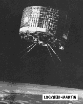
(SRTM in the shuttle cargo bay. NASA image.)

Over its 11-day mission, the SRTM mapped over 99% of the earth’s land area between 60 degrees N latitude and 56 degrees S latitude. The SRTM instrument consisted of a large radar array in the shuttle cargo bay and a smaller antenna mounted on an extendable mast: the mast, the longest rigid structure yet flown in space, placed the secondary antenna 200 feet (60 meters) outside the shuttle. The configuration caused an increase in fuel consumption as the shuttle had to “offset the gravity gradient torque of the mast,” but they were able to compensate and complete the mapping mission.

Endeavour is in orbit today on mission STS-130, its next-to-last mission to the International Space Station. Fare thee well.

Facebooktwitterpinterestlinkedinmailby feather

Our Geeky Church, and a Little Space History

Before we get into today’s space history, a “quote of the day” from last night’s small group Bible study. As we were gathering, Maria grabbed one of our STAR TREK coffee mugs for Elliott, so I mentioned that ReConStruction, the North American Science Fiction Convention (NASFic) is coming to Raleigh in August. True to the nature of our science fiction church, Elliott said, “If that’s not a church trip, I don’t know what is!”

Yes, we’re geeks. But you already knew that, didn’t you?

Back to the topic at hand, an interesting launch 40 years ago in space history. On January 23, 1970, a Delta rocket out of Vandenberg AFB carried two satellites, ITOS-1 and Oscar-5.

ITOS-1 was the first prototype of the “Improved TIROS Operational System” — that is, a new and improved version of the remote sensing satellite featured in yesterday’s space history item. ITOS-1 was built “to provide improved operational infrared and visual observations of earth cloud cover for use in weather analysis and forecasting.”

Oscar-5, on the other hand, was an amateur spacecraft built by students at the University of Melbourne, Australia. It has the distinction of being the first remotely-controlled amateur micro-satellite.

Facebooktwitterpinterestlinkedinmailby feather

Remote Sensing, 60s- 70s-Style

Forty-five years ago today — January 22, 1965 — the Tiros-9 satellite was launched from Cape Canaveral atop a Delta rocket.

(Tiros satellite. Lockheed Martin image from JPL Mission & Spacecraft Library. Click to enlarge.)

Tiros-9 was the first of the Television Infrared Observation Satellite (TIROS) series to be launched into a polar orbit. Intended for a sun-synchronous orbit, it ended up in a highly elliptical orbit due to a failure in the onboard guidance system. Tiros-9 was also the first meteorological satellite to operate in a “cartwheel” fashion in which the “spacecraft spin axis was maintained normal to the orbital plane” by means of electromagnetic torque between an electrical circuit loop in the vehicle and the earth’s magnetic field. Tiros-9 suffered a series of system failures and ultimately retired from service in February 1967.

Ten years after Tiros-9, and on the other side of the continent, Landsat-2 — another remote sensing spacecraft — launched from Vandenberg AFB. Landsat-2 also launched on a Delta rocket. As proof of how much had been learned about spacecraft design in the interim, Landsat-2 remained operational over three times as long as Tiros-9: it retired from service in February 1982.

Facebooktwitterpinterestlinkedinmailby feather

Apollo Test Launch, 45 Years Ago, and Lunar Mapping Today

Forty-five years ago today — September 18, 1964 — NASA launched a Saturn-1 booster from Cape Canaveral in mission SA-7, also known as Apollo “Boiler Plate 15.” The launch demonstrated the Launch Escape System (LES) for the first time.

Anything Apollo-related of course reminds me of the moon, but I’ll skip the shameless plug in favor of some exciting news about the current LRO mission:

After two months of checkout and calibration, NASA’s $504 million Lunar Reconnaissance Orbiter was maneuvered into a circular 31-mile-high mapping orbit Tuesday and scientists said Thursday the spacecraft’s instruments are delivering intriguing clues about the possible presence of water ice.

The exciting news and “intriguing clues” are indications that hydrogen deposits may exist not only in permanently-shadowed craters near the south pole, but elsewhere on the moon as well — perhaps buried under lunar soil. Whether they’re water, or ammonia, or methane, or something else is unclear, but there appears to be something there, and probably something useful. Read the whole Spaceflight Now report here.

Facebooktwitterpinterestlinkedinmailby feather